April 25, 2012 — Staff from the Scholars' Lab in the University of Virginia Library hoisted a tethered weather balloon hundreds of feet above Clark Hall last week to demonstrate do-it-yourself aerial photography techniques for students, faculty and staff.
The idea was to show how researchers can use inexpensive aerial photography techniques and geographic information systems technology, or GIS, to quickly gather aerial images and data and stitch it into a map. The workshop was one of three on the subject hosted by the Scholars' Lab last week as part of an ongoing series.
"We get requests from students all of the time," said Scholars' Lab GIS specialist Chris Gist. "They'd like to have recent high-resolution imagery for a project, and right now the best we can do is to use aerial images that the state periodically obtains. But if they want photos after an event, or to measure something every couple of weeks, there wasn't an option. So we started looking for low-barrier ways to do this."
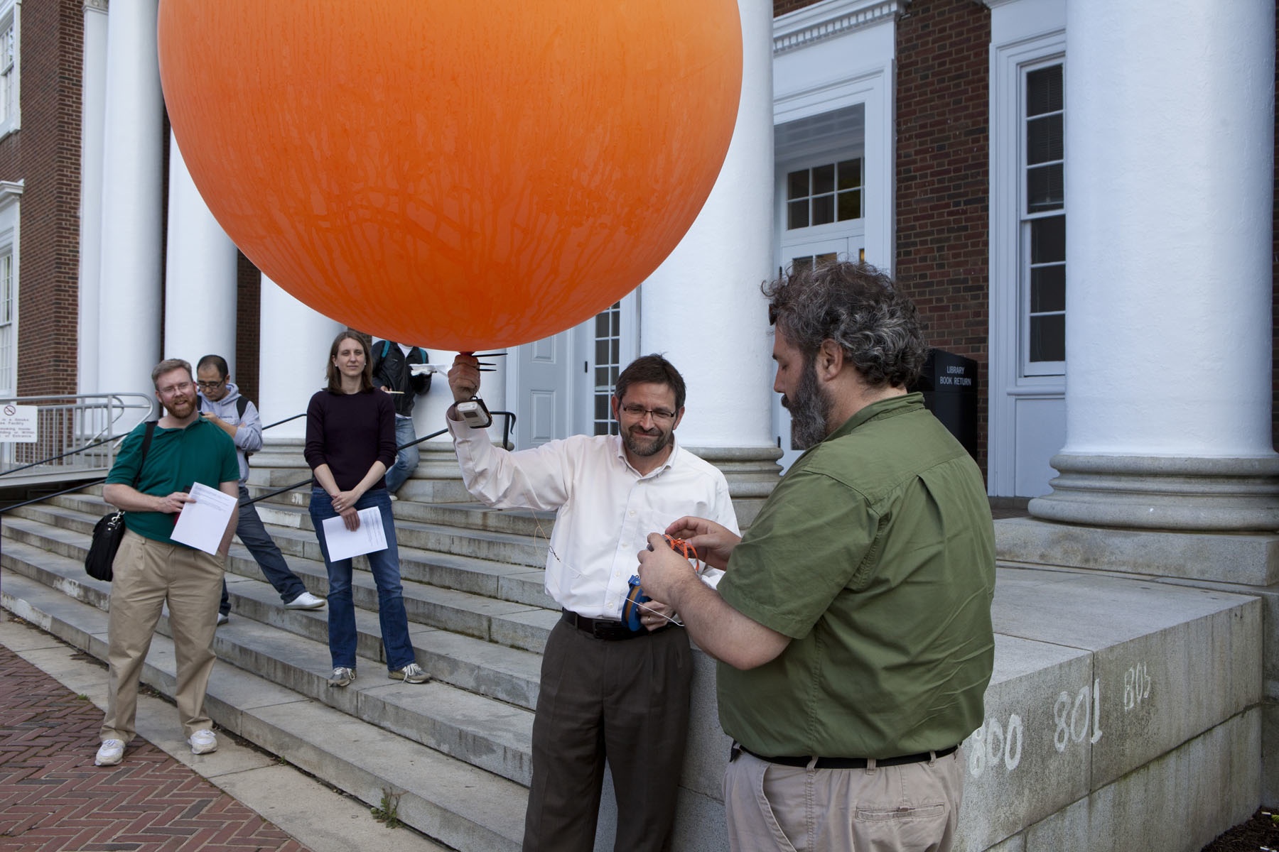
Outside Clark Hall on Thursday, Gist and fellow GIS specialist Kelly Johnston mounted a point-and-shoot camera and a GPS into a protective casing made from a plastic bottle, complete with a homemade tailpiece designed to keep the camera from spinning when aloft. They attached that to an orange weather balloon connected to about 1,000 feet of deployable tether.
"We take our weather balloon and we attach our flight line to it, and then we put the whole camera up in our homemade rig here," Gist said to the assembled crowd as he attached the equipment.
The camera could be set either to shoot every few seconds or to record video. After turning it to "video," Gist released the balloon, which began to rise toward the roof of Clark Hall, with Johnston manipulating the tether to steer it.
The concept for the kit they used originated with a company that needed to do quick and inexpensive aerial photography in the Gulf of Mexico after the 2010 oil spill, Johnston said. The entire rig – minus the camera – cost less than $100.
"They were using it in the Gulf to try and map beaches and monitor the oil impact there," he said. "They came up with this as an inexpensive way to do do-it-yourself aerial photography."
John Porter, a research assistant professor in the Department of Environmental Sciences attended Thursday's demonstration – he supplied the GPS that went up with the balloon – and said that part of the technique's advantage is that you can immediately retrieve the images.
"You have it right under your control if you want to get aerial imagery immediately after an event – a storm, an oil spill or something big that has happened and changed a system," Porter said. "If you wanted to book a company to fly in and do metric aerial photography, you might be waiting weeks or months to get it, and it might take a long time to get the data back."
Guoping Huang, an assistant professor in the School of Architecture, also attended the workshop and said he plans to use a similar technique in an upcoming research project that deals with how students use public space on Grounds.
"One way to keep track of the use of public space is to send students out to do observations, but this is very time-consuming and requires a lot of students in different areas," Huang said. "But I think using aerial photography to monitor the movement on the Lawn and the use of public space will be a much easier option."
Though windy conditions prevented the balloon from flying as high as it might have – it attained a maximum altitude of 345 feet – Gist and Johnston were able to retrieve several minutes of video, now posted online. They were also able use the GPS data to chart the balloon's course in Google Earth.
Scholars interested in similar projects could use still images to create aerial maps, or could periodically deploy a balloon to track change over time in a given area, Gist said.
Handouts, slides and other resources are available from the GIS workshop website.
– by Rob Seal
Media Contact
Article Information
April 25, 2012
/content/scholars-lab-uses-do-it-yourself-kit-capture-birds-eye-view-grounds