The news is increasingly peppered with stories of “sunny day” flooding (high tide-flooding not associated with storms) along the Virginia coast. Parts of the city of Norfolk frequently – and increasingly – get flooded. Miami and other cities along the U.S. East Coast experience this type of flooding as well. And the problem will worsen as sea levels continue to rise.
Q&A: Coastal Researcher Discusses ‘Shocking’ Flooding During King Tide
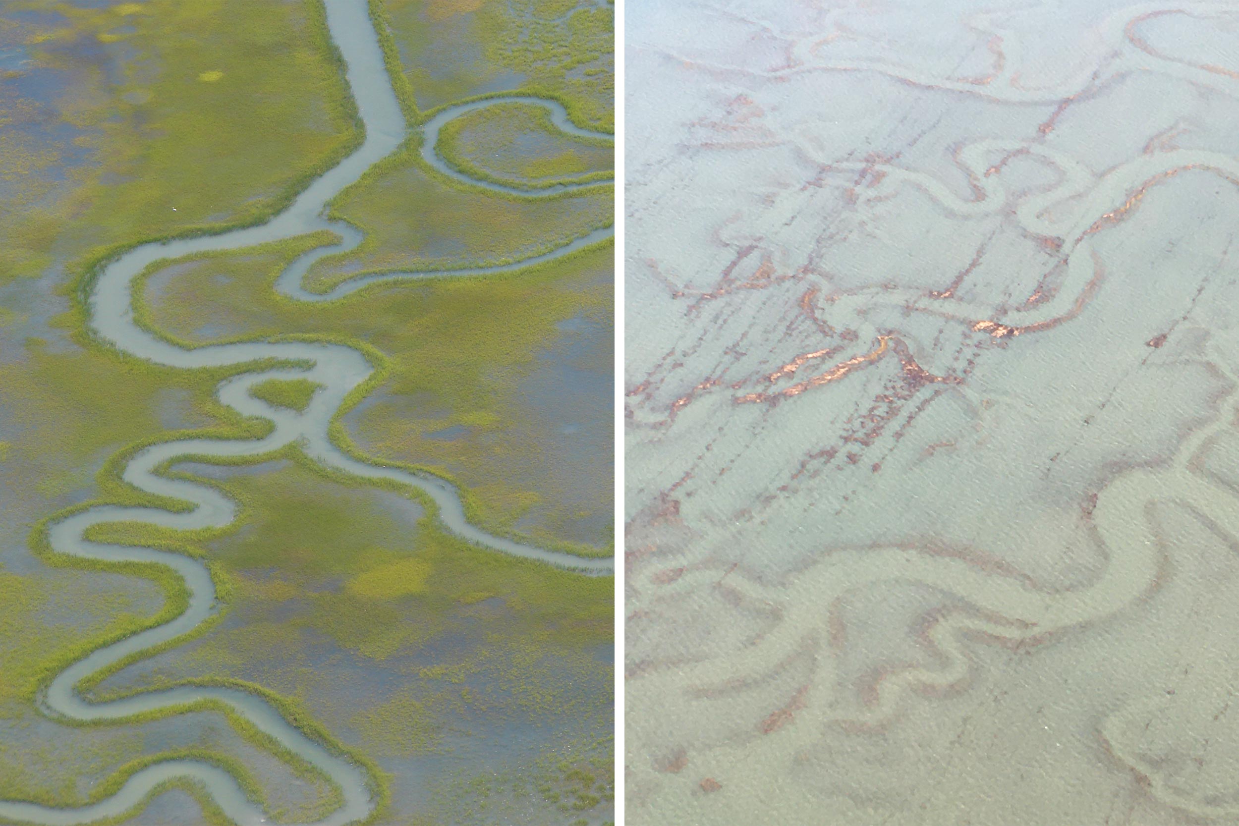
The king tide flooded extensive saltmarshes on the seaside of the Eastern Shore. Left is a marsh at normal high tide; right is marsh during the king tide – the highest of the year. (Photos by Fariss Samarrai, University Communications; and Cora Johnston)
Researchers at the University of Virginia’s Anheuser-Busch Coastal Research Center on the Eastern Shore are studying this phenomenon and the many other effects of climate change on the natural environment and coastal communities. In October, Cora Johnston, the site director at the research center, went on a low-altitude flyover of the coastal marshes and barrier islands of the Eastern Shore, as well as over Norfolk, to photo-document what happens to that area during the highest predicted tide of the year – a “king tide.”
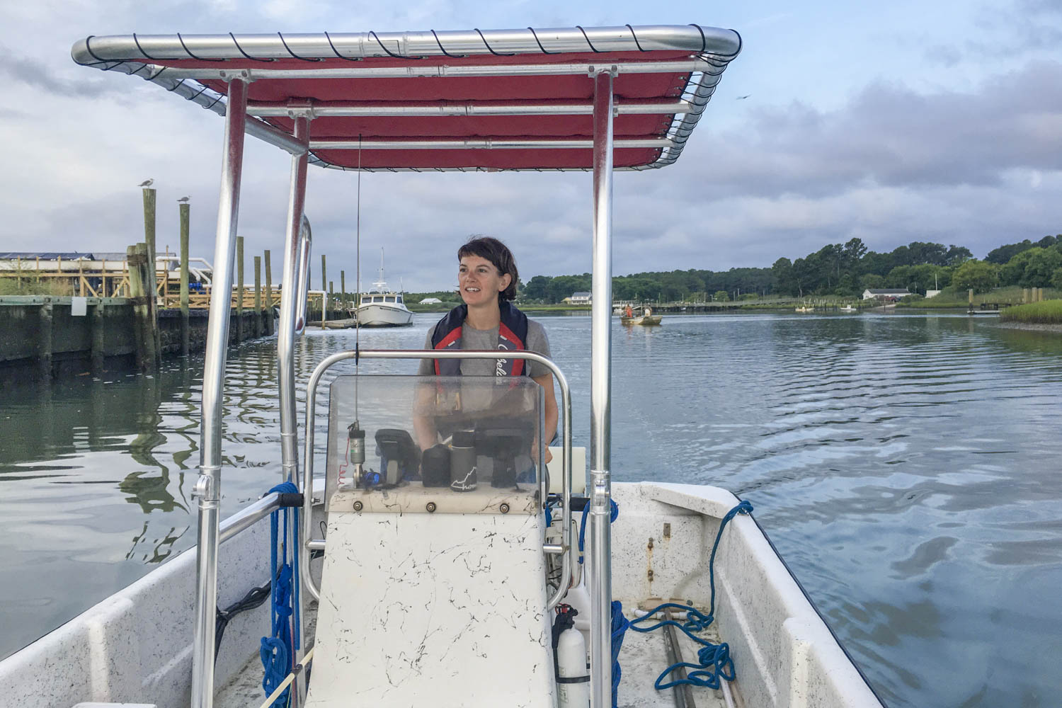
Cora Johnston runs UVA’s Anheuser-Busch Coastal Research Center in Oyster, Virginia. (Photo by Maya Wheeler)
While Johnston and her research colleagues took to the sky, hundreds of Eastern Virginia residents documented the event from the ground via an app created for the Virginia Institute of Marine Science. The goal was to document the exceptional flooding of the king tide, and glimpse the future, in a sense, when sea levels are higher.
UVA researchers have been studying coastal ecosystems, erosion, barrier island change and sea-level rise at the Eastern Shore since 1986, with funding from the National Science Foundation’s Long Term Ecological Research program. Among 241 public data sets produced by researchers studying at the Eastern Shore are data that capture changes in coastal elevation over several decades. The combination of marsh elevation data with related tide, meteorological and vegetation data makes the study area a sentinel for sea level rise along coastal Virginia. It is one of eight official sites in the Chesapeake Bay Sentinel Site Cooperative, a NOAA-funded initiative to enhance regional insights on coastal change.
Johnston discusses her king tide flight for readers of UVA Today.
Q. Why fly during the king tide?
A. The king tide is the highest predicted tide of the year. It is an astronomical tide, which means that the sun and moon are aligned such that their gravitational pull creates the highest tide of the year. These exceptionally high seasonal tides provide a glimpse of what our land will look like as seas rise.
Areas that currently flood only during king tides will flood more frequently as sea levels continue to rise. Areas like Norfolk already see more sunny day flooding with each year.
Flying during the king tide provided an illustration of what is in store in the very near future. Challenges presented by flood waters once or twice a year now will become more of a nuisance as waters more frequently reach those levels.

Graying trees and thinning forests encircle a site where UVA researchers have documented changes in marsh elevation for more than 20 years. The formation of these ghost forests indicates rising sea levels and marsh migration inland. (Photo by Cora Johnston)
Q. What is the purpose of this flyover?
A. The Sentinel Site Cooperative, represented by researchers from the University of Virginia and the Chesapeake Bay National Estuarine Research Reserve, took to the air with a local reporter and volunteer pilot to compare sites across the cooperative network and to share a vision of coastal Virginia’s future as seas rise.
Data from our sites reveal that wetlands are responding differently across coastlines even within the Chesapeake. This flight brought that insight to life, clearly illuminating the traits of the varied landscapes that we are working to unify for policymakers and managers. The aerial view provided a new perspective – a chance to see patterns and assess happenings with a fresh mind.
The flight also helped level the conversation among those in flight, providing a shared view and experience around which to have an honest conversation about coastal resilience.
Q. What insights did the flight provide?
A. The entire crew – even the seasoned researchers – were shocked by the amount of flooding evident during the high tide. On the seaside of Virginia’s Eastern Shore, the entire marsh system behind the barrier islands was flooded beyond recognition. An endless view of water replaced the usual creeks that wind through expanses of saltmarsh – home to beloved fisheries species and world-renowned migratory bird populations. Boat ramps used daily by watermen and researchers were inaccessible; entire docks submerged by the tide.
In Norfolk, flood waters are already approaching major buildings and downtown infrastructure. The necks and spits of the Middle Peninsula – around Gloucester – highlighted the uncertain future of communities and businesses accessible by a single, already flooding road. Saltwater rested at the foot of coastal forests, where dying “ghost” trees have alerted researchers to encroaching waters.
Along with the photos we took, the Coastal Resilience App, a decision-support tool built with our data, provides a way for anyone to see what the Eastern Shore will look like with more high water.
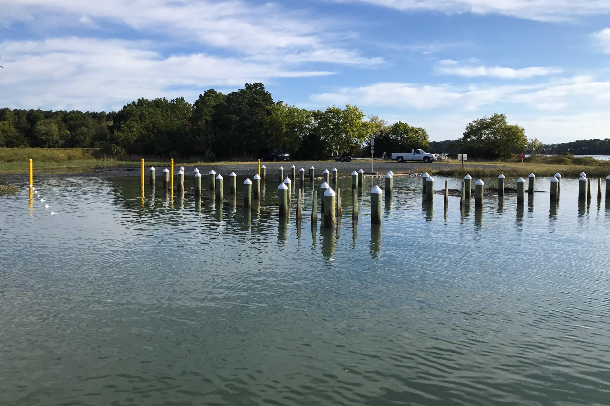
The king tide flooded infrastructure, like boat ramps used daily by commercial watermen. As sea levels continue to rise, these flooding events are expected to increase. (Photo by Jonah Morreale)
Q. What happens next?
A. Researchers from UVA and partner institutions are continuing research on coastal change. 2020 will be our 22nd continuous year of collecting marsh elevation data. We are also launching new studies of coastal change, including a massive experiment on the formation of ghost forests as coastal trees die.
Along with adding another record to each of our long-term data sets, 2020 is expected to bring a collaborative workshop for coastal decision-makers and an arts collaboration inspired by coastal change.
In January, more than 60 scientists will gather once again for an annual meeting to plan and share new initiatives, many of which are directly linked to coastal management and policy.
Additional images of high waters on the coast of Virginia can be found by exploring the work of aerial photographer Gordon Campbell, who has hosted UVA research outreach events and collaborated on educational projects.

TrendingThis Week


Media Contacts
University News Associate Office of University Communications
farisss@virginia.edu (434) 924-3778