
Hamilton Lombard isn’t a Civil War buff, but like many people, he’s heard the story of Wilmer McLean, who just couldn’t escape the war.
In 1861, McLean’s farm near Manassas was involved in the First Battle of Bull Run.
Looking to flee the fighting, McLean and his family moved to Appomattox – and wound up being right in the heart of it once again. In 1865, Robert E. Lee surrendered to Ulysses S. Grant – in McLean’s house.
It was with McLean’s plight in the back of his mind that Lombard, a state demographer at the University of Virginia’s Weldon Cooper Center for Public Service, thought it would be interesting to measure the demographic impact of the Civil War in Virginia.
“What I wanted to know was, on a county level in Virginia, which areas were more impacted?” Lombard said. “Can we actually identify specific counties, specific regions that had more deaths or dislocation than others?
“A lot people would say that most of the military action was between D.C. and Richmond. So I thought, ‘Let’s check that. Are those the areas that were also the most impacted?’”
Using digitized historic census age data and a methodology similar to the one the Cooper Center uses to project future Virginia populations, Lombard made several notable discoveries, which he discussed recently.
Q. Which county in Virginia did you find was most affected by the Civil War?
A. Alleghany County. Its population had been growing rapidly before the war and nearly doubled in the 1850s, but it was halved during the war.
It had a massive impact. Its population didn’t get back to where it was in 1860 until 1890. There was basically a three-decade delay.
There was almost no military action in Alleghany County during the Civil War. It was sort of this knock-on effect. The war not only resulted in a lot of deaths and refugees, but it also stopped development in a many parts of Virginia. You can see that in western Virginia. It stopped and reversed development there.
There are a lot of “what-ifs.” What would Alleghany County be like today if there hadn’t been the war? If its population was exploding and then completely stopped and never got back to where it was for another 30 years, would its population be much larger today without the war? Would one of Virginia’s larger cities be in Alleghany County?
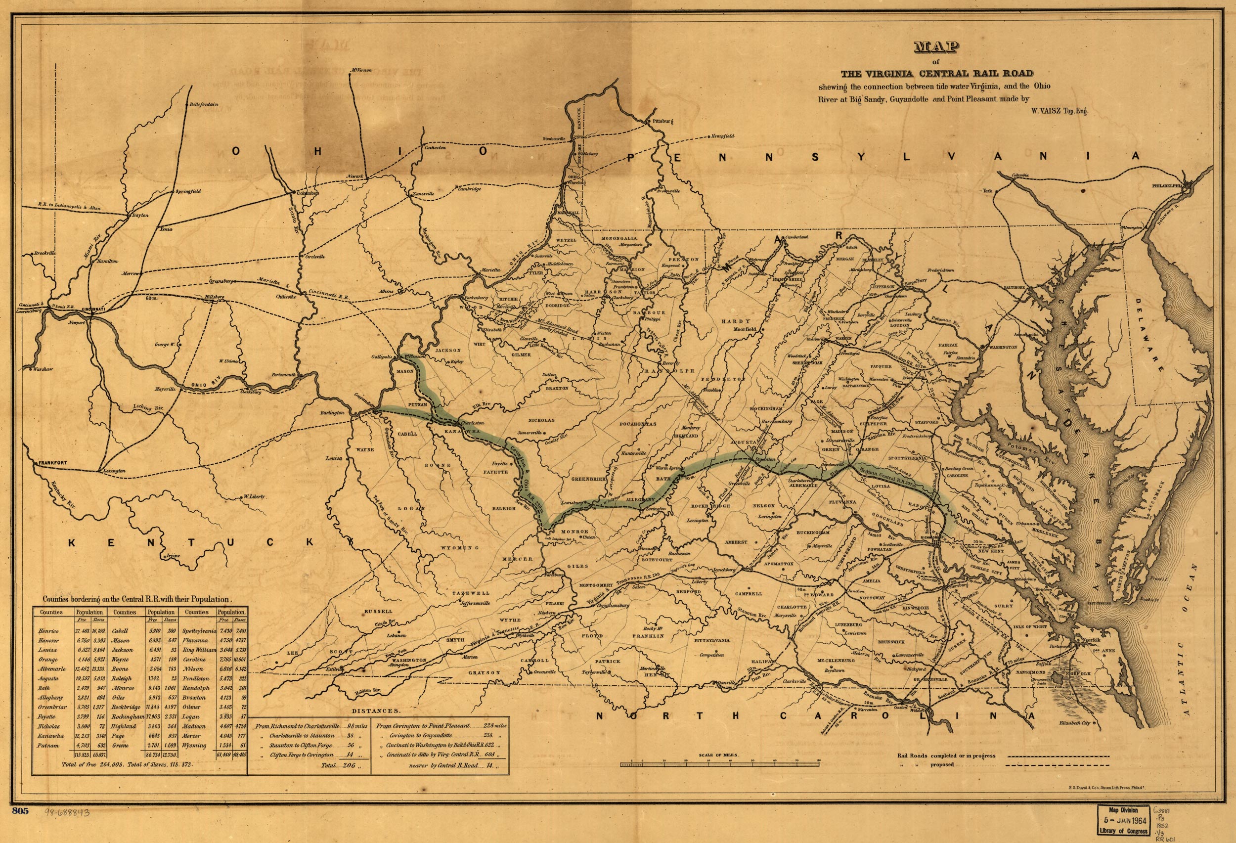
A map shows the intended route of a rail line that would have connected western Virginia with the Tidewater region. (Courtesy Library of Congress)
It’s extraordinary when you look at the impact in Alleghany. You look at it and you see that the railroad – which goes right through Grounds – was being extended out there, and it just stopped during the war. You had forges and mines opening, but the war stopped that. The Union heavily targeted them and tried to destroy anything that they could so that it couldn’t be used for the South’s war efforts. But that really stopped the development and it took a long time to recover.
Q. What was your biggest surprise?
A. The big one was the impact of the war in areas where there was relatively little military action, particularly in Southwest Virginia. A number of southern and western Virginia counties were actually the most impacted areas in all of Virginia. And the reason why, when you start looking at it, is you had a huge amount of industrialization taking place in the area before the war. This was where the coal fields were being opened, forges constructed and where the railroad track was being built that connected eastern Virginia with the coal fields. The war stopped all of this.
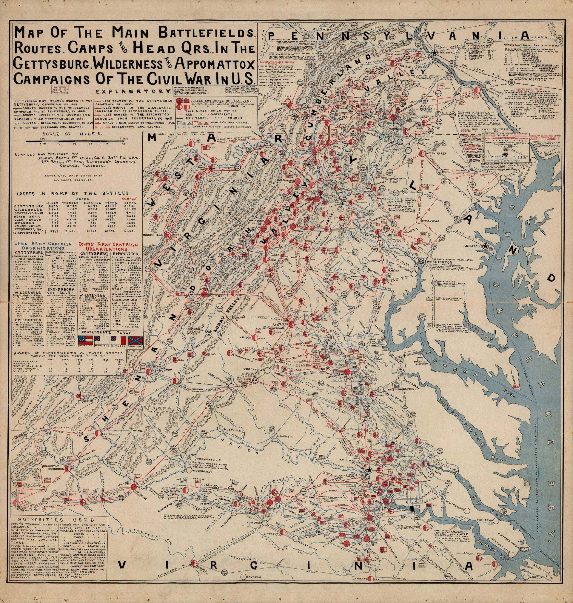
A map shows military actions in the second half of the Civil War in Virginia. (Courtesy Library of Congress)
Q. What were some other takeaways?
A. In 1870, some parts of Virginia had larger populations than expected as a direct result of the war. Two notable areas with much larger-than-expected populations were Northern Virginia and Hampton Roads, which, if you know much about the period, had large contraband camps which were essentially for slaves who had run away or been dislocated by the war, and the government put up the equivalent of refugee camps for them. Five years after the war, the areas still had much larger black populations than before the war.
Overall, the war had a larger demographic impact on black Virginians than white Virginians.
Q. What did you learn about Charlottesville and Albemarle County?
A. I think one of general patterns I noticed is that counties right near the front lines had much fewer people than expected in 1870. But then you have counties that are relatively close to the front lines, but a safe distance away, such as Albemarle and Charlottesville – those areas tend to have more people than you expected, or just slightly less than you expected, and that’s probably because they attracted a lot of refugees and people trying to get away from the war.
So when you look at Albemarle and Charlottesville as a whole, its population was only 2% less than expected, which is a much smaller impact than Virginia overall.
As you go further from the battle front, the negative impact of the war gets smaller. In Nelson County and some other Blue Ridge counties, there were actually more residents than expected, and I think it’s because they attracted a lot of refugees.
Q. From a mechanics perspective, are you pleased with how your study unfolded?
A. This was a really unusual project to work on. We rarely look at population data that is more than a few decades old, but I thought it would be interesting to explore. It can help us with a lot of the work we do today with understanding variations in census data and how age cohorts grow or decline over time.
The nice thing with Virginia is that its county boundaries were fairly stable during the mid-19th century, so you have comparable populations over time. If you tried to do this, for say, in Arkansas, it’s not going to look as interesting because you would have to lump most of the counties together and only have six or seven. So Virginia was quite well-suited for this.
That said, it would be fascinating to conduct a similar analysis of the war’s impact in other states.
In my mind, this doesn’t answer all the questions about the impact of the war in Virginia. What it does do is provide a county-level comparison. If you’re somebody who’s studying a specific part of Virginia in that period, hopefully it will be a resource to look at. It can put whatever area you’re studying into context.
Media Contact
Article Information
April 23, 2019
/content/why-alleghany-county-was-virginia-locality-most-affected-civil-war